
Tsunami Preparedness Week is March 21 – 29, 2026. This is a great opportunity to learn about tsunami hazards in your community. Find out how to tell if a tsunami is headed your way and what to do. All coastal communities are vulnerable to tsunami hazards, and during Tsunami Preparedness Week organizations and communities work together to practice their drills and review their response plans.
How do I participate?
Visit the TsunamiZone.org website to register and participate in Tsunami Preparedness Week.
Plan your Tsunami Walk for a time that works best for you! You can evacuate alone or include your family, friends and even coworkers. All are welcome in a Tsunami Walk!
How to Plan a Tsunami Walk!
Check out what’s happening in your community. Tsunami Preparedness Week is being observed across Del Norte, Humboldt and Mendocino counties.
The National Weather Service and County Office of Emergency Services will be performing tests of their notification systems. Join us in practicing by signing up for County emergency alerts or working with your family and/or neighbors to develop your plan and practice your tsunami evacuation drill.
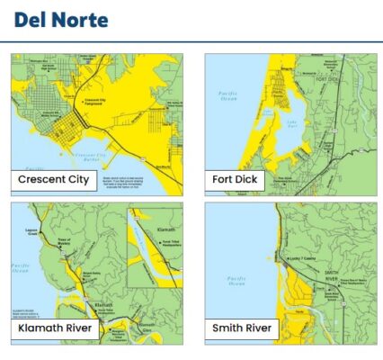
Find where you live or work on the maps or use the State’s interactive map at tsunami.ca.gov. If you are in the YELLOW area, plan a safe evacuation route to the nearest green area.
Tsunami mapping identifies areas that could be flooded by a tsunami. The California Geological Survey (CGS) is responsible for creating our tsunami maps. CGS identifies all possible tsunami sources and models the flooding extent. The models are combined to identify a WORST-CASE line. For Humboldt and Del Norte Counties, the largest tsunami is caused by an earthquake on the Cascadia subduction zone, estimated to be around a magnitude 9.0. In addition to the use of the worst-case scenario earthquake, several assumptions are factored into these maps. It is assumed that the tsunami arrives at high tide and that some land level subsidence (dropping down of the land) occurs during the earthquake. This provides a landward extent of the tsunami flood model that is further extended to the nearest elevation contour plus an additional 1-meter vertical elevation is added to determine the boundary between the yellow and green zones.
On the North Coast, four schools are currently located within a tsunami hazard zone: Manila and Samoa schools in Humboldt County; Uncharted Shores Academy and ‘O Me-nok Learning Center in Del Norte County. These schools have plans in place for response to a local earthquake and tsunami. To learn more about the plans your child’s school has regarding earthquake and tsunami safety on the North Coast, we encourage you to contact the school directly.
The Del Norte Office of Emergency Services shared a resource called Living on Shaky Ground, which provides information on how to prepare for, survive, and recover from earthquakes and tsunamis. The guide includes steps to help save lives, reduce injuries, and minimize damage.
Residents can download the guide at rctwg.humboldt.edu/prepare/shaky-ground to learn more about local preparedness actions.


